


The first big climb
- Jun 7, 2022
- 10 min read
After enjoying Oregon's coast we turn inland and head toward our first real climb through Mckenzie Pass. Well, actually Santiam Pass since we found out Mckenzie Pass is still closed due to snow (what? Only 6,000 feet and its late May but Oregon is not Southern Utah). In addition to the climb we face a weather challenge as the overcast has turned to rain. Rain itself is manageable but thin shoulders and heavy traffic get downright dangerous when pavement is wet and visibility is reduced. We also continue to learn bike/trike maintenance as we progress through Oregon and encounter issues. On our hike it was about physical issues (knees, plantar fasciitis, blisters etc) and we had fewer equipment issues. On the TAT trip, it is more about equipment issues (tubes, tires, chains and chain tubes) with fewer physical challenges. Still time for the physical to catch up and that big climb may balance the ledger. We will see.
Day 5 - 60 Miles to Mckenzie Search and Rescue Station in Leaburg, Oregon
Yep, that is a big 60 mile day. With a whopping 830 feet of climb. Amazing how the flat terrain is SO much easier. We got off to a reasonable start after a light breakfast at the Super 8 we biked 24 miles to Harrisburg and had second breakfast. We stopped at a bizarre little market where they offer great prices because everything is past its expiration date (some items were way past). Needless to say we picked our drinks carefully. After second breakfast, we headed down to Coberg. Lots of fields, mostly tall fescue. Was a little groundhog day with the flat terrain and repeating grass fields but the miles whizzed by.
In Coburg, we had to figure out our accommodations for the night. As we head east toward Mckenzie Pass the TAT goes through more rustic areas so the choices are slim. I tried to call county parks but they didn't answer. Next I called a fire department and they said we could camp on their lot. The are in Leaburg so that requires a 60 mile day. Turns out that was a good thing since it started sprinkling just outside Coburg and was raining 24 miles later in Leaburg. Erik and I had just tucked under the eave at the fire station when the skies opened and it poured for 15 minutes. I am grateful that prayers are answered and the heavy rains were delayed until we found shelter.
We will stay dry tonight but the rains continue for three more days so we are going to get wet. We are also climbing almost 6,000 feet in the next two days so that + the rain will certainly test our resolve. After that, we should be in Sisters Oregon where the TAT and PCT intersect. Cannot wait to be in Sisters for all kinds of reasons. We will take it one day at a time and see how tomorrow goes.
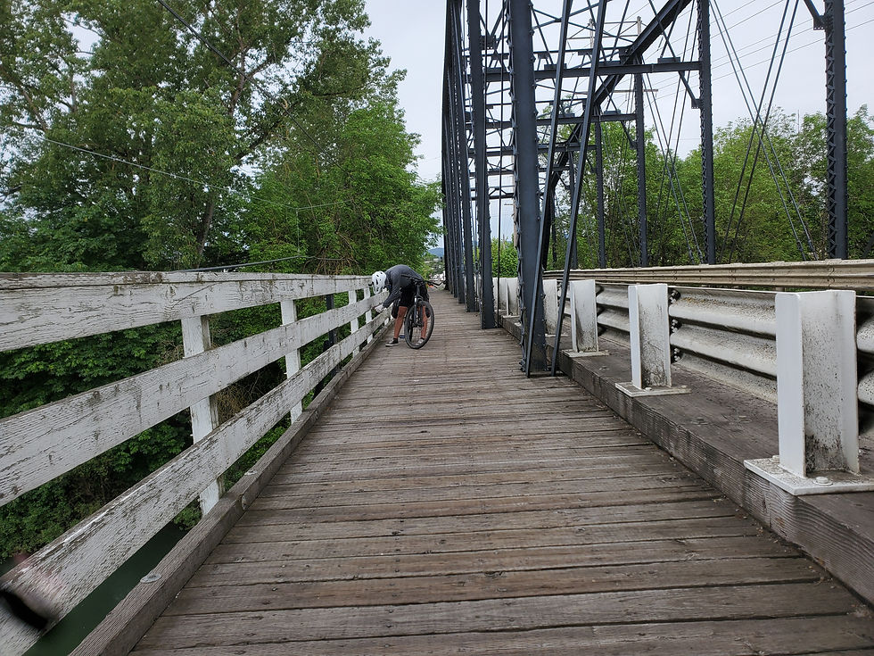
We start the day crossing this wooden bridge. With biking all the rivers have bridges and the only ford's we have to worry about are trucks

Flowers brighten every day - even overcast ones

This driveway was bracketed by these two massive trees. Why do I love big trees?

Even little wild flowers change a landscape

We moved from coastlines to riversides. There is so much water up here

We passed these cool high tech bee hives on one of the fields. Do the bees react to the different colors?

We passed this field and could smell all the flowers even from the road

I am amazed with the colors and diversity of wild flowers. These are not someone's work, these are just nature's gift.


We passed a menagerie with lamas, wild turkey and who know what else

Glad we didn't have to cross this bridge, see how high the Mckenzie River is running

Erik setting up camp at the Mckenzie River Fire Station

I didn't risk more rain, so I slept under the station eave
Day 6 - 26 miles to Harbicks Country Inn
The fireman were up early so we were up early. Still raining this morning but we are committed to getting up the pass. Best laid plans . . . About two miles down the road Erik pulls up with a bump in his back tire. Initially he thought it was a rock in his tread but it was a screw - right through the tire. Luckily the goo in his tire held pressure until we made it back to the fire station (another tender mercy :)). We pulled and patched the tube - still won't hold pressure. Upon closer inspection the screw went through BOTH sides of the tube. No patching that so instead we Uber back to Springfield to the closest bike shop. New tire, new tube and a spare tube to boot then another Uber back to the fire station. At the bike store we find out there is still snow in Mckenzie Pass and it's closed (St George Boys don't think about snow covered passes in late May). With this new information, we adapt our plan. We put Erik's tire back on and head back into the rain toward Mckenzie Bridge. The weather is supposed to be poor all weekend. We don't want to try the alternative summit in cold, windy rain. So, a zero tomorrow and then hopefully better weather when we push up Santiam Pass and then on to Sisters. Final note for the day, once we settled into the lodge I found my chain has split its guide. Need to sort a temporary solution and hope to get it fixed in Sisters. Have never toured before so maybe having all these equipment issues is normal. In six days we have replaced one tire, two tubes, a derailleur gear and need to replace a chain guide. In days . . . Has to get better - never had these types of issues with our hiking gear. Oh by the way, all this fun was my birthday present from the TAT. (Actually my present is being able to be out having this adventure - thank you dear 😘).

This fuzzy white moth joined us for breakfast

After 2 miles Erik got "screwed" as this screw went through his tire and tube

After a trip to town and a new tire we passed the 250 mile mark - Yea!
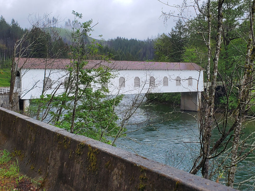
A cool covered bridge, reminds me of New England on the AT
All the rain has spawned some pretty waterfalls along our route

Loved it went when the road entered this majestic stand of pines

From sea level up to 1,000 feet, only 10,000 feet to go :)

Last flowers of the day.
Day 7 - 0 Miles waiting out the rain
Zero day musings, comparing hiking to biking. After a week on the TAT I find myself making comparisons to our AT experience. There are some advantages to biking. We cover longer distances which opens up more options and we are typically traveling near infrastructure so there is less worry about access to food and water. In addition, we are a week in and I have yet to dig a single cat hole. On the downside, when biking we don't just have to worry about maintaining our bodies we also have to maintain our bikes. When hiking, I never worried about my backpack failing and when issues did arise (leaks in an airpad etc) they were easily managed and repaired with little skill required. Maintaining the bike involves some small, manageable issues but there are also major issues to worry about. We can fix a flat but what happens when a screw goes completely through your tire? Or, a derailleur bracket shears off or a chain tube fails? Unless you pack a full bike worth of spare parts and are a great bike wrench yourself there is no way to manage the breadth of issues introduced by bringing a bike on trail (this may be an overreaction to a bad first week of maintenance issues but it is definitely a difference between hiking and biking).
Another major difference is your surroundings. When biking there are some awesome times when you are all alone on a mountain or farm road and you can enjoy the solitude and your surroundings. But there are also many miles where you are hugging the shoulder (what the TAT lovingly calls a "bike lane") while masses of traffic buzz by your shoulder going 65. When hiking, you occasionally pass through a town or over a freeway, but most days you are away from the noise of the world.
A third difference I noticed is the culture of the trail. The AT and PCT have their own eco-system. There are terminuses, trail markers, trail towns and trail angels. There hostels, shelters and other hikers (sometimes too many) to lend support along the way. And almost everyone understands what the trail is and what you are doing. There are little markers at key mile marks and milestones to encourage and celebrate progress. There is just a strong trail culture that you feel a part of. Thus far along the TAT there has been no sense if culture. There was no terminus marker at the start or trail markers along the way. We pass through towns, but they are not "trail towns". Few people or businesses know what the TAT is or that it runs through their town. We are just customers on bikes, not part of anything bigger. Not sure why that matters but it does. When doing a hard thing, it helps to have that recognized and to feel part of a greater culture. So far, I have missed that on the TAT.
Still early for a definitive conclusion but thus far I would say that I prefer the hiking experience.

A Bigfoot near the Lodge where we hid from the rain for a day.
Day 8 - 56 Miles to Sisters, Oregon
WHAT! 56 miles today including going up and over the Santiam Pass? Guess that day off was helpful 🙃. We got a kind of early start for us (8 AM) and headed down the road into the drizzle. We did a quick 8 miles and passed the turn off for Mckenzie Pass with the closure sign :(. Then we pushed forward toward Santiam Pass as our alternate route. It adds about 12 miles to our day and isn't as pretty but on an overcast and rainy day we probably won't notice. Lucky for us the grade is mostly under 6% so we can keep pushing through without stopping. Easily the longest climb we have done as the lift just kept going and going. We had rain, a glimpse of sun, then more rain and a touch of snow near the top. After all that work, I was expecting a sign saying Santiam Pass, 4,817 Feet or something impressive, we got nothing. In Maine they put a sign on top of everything. A bit anticlimactic but we were thrilled to be at the top and the pass itself was beautiful. The worst part was actually heading down the back side. Six continuous miles of downhill sounds like a great thing. But when the wind is blowing, the rain is falling, its 40 degrees and the trucks pulling fifth wheels are six inches away it can be a little stressful. So glad the breaks worked 💪 After bombing down the hill, we actually had the sun pop out and warm us and dry us the last twelve miles. We arrived at the Left Coast Lodge around 3:45, settled in, showered and had dinner. A much better day than expected. We will see how the legs feel tomorrow.
For those wondering about the chain tube issue, here is what happened. During our down day yesterday, I did a little work on the tube. It was in worse shape than I thought as it was split in three places. I borrowed some duct tape from the innkeeper and patched it as best I could. I also adjusted the mounting clamps that hold and position the chain tube. I am not a very good wrench but when I started riding this morning, the chain was no longer hitting the tube, it flowed smoothly. How did that happen? Some may call it good luck but i know better. It is one of the many tender mercies and little miracles that I have experienced already on this trip. Prayers are answered after we do all we can do ;).

Mckenzie Pass is still snow bound so we will cross Santiam Pass

Erik starting the climb up
All the rain created some beautiful waterfalls as we climbed the pass. Every cloud has a silver lining

All the rain also generates lots of new growth

And then a random lava flow . . . Reminds me of Cedar Mountain back home

Note the snow on the mountains behind and the great weather for climbing a pass

Santiam Pass - we can see the road above and know where we need to climb

On the other side of the pass we cross the PCT. Was a cool moment as two trails we love intersected.

After fighting through rain, sleet, snow and hail to get over Santiam Pass, we freeze down the backside and arrive in Heaven as the sun comes out just before Sisters.

Love running down these pine sided byways. It's like hiking but with traffic :).

Erik and I finally pull in to the Left Coast Lodge in Sisters.
Day 9 - 54 miles to Ochoco Lake County Park
So nice to arise to a sunny morning:). We enjoyed our time in Sisters. We had a good Mexican dinner last night (seafood enchiladas) and smoothies this morning after sleeping in super comfy beds last night. It was quite a contrast heading out on a dry sunny day and looking back at all the snow and rain up in the pass. We quickly left town and the main road and returned to the country. To provide some variety, however, the TAT didnt take us by more wineries and hay fields. Today we were in horse country and saw some beautiful animals. We also passed three different Alpaca farms with large herds of lamas running around. I kept thinking of Cusco.
The day started sunny but it was still cool with highs in the 50s and lows in the 30s. We are not really prepared for the cold and hope things warm up before we gain much more altitude. Not a problem at night as we have 25 degree bags but when that cold wind blows while you are riding - brrrrr.
We ran into three people today that knew what the TAT was and provided some suggestions. That felt better 😌. Based on those suggestions we are targeting a TAT based hostel near Mitchell, Oregon for our stay tomorrow night. Tonight it is the tent (sanctuary :)).

We could find a back light or reflector for Erik's bike do we bought a package of trail tags and hung them all over his packs. McGuyver would be proud.

Looking back toward the pass we went through. Good bye snow (we hope).

Mount Washington. We have to pass a Mt Washington on every trip

A Tom turkey strutting his stuff

Going through horse country had me thinking of Rachel

And wildflowers had me thinking of Peggy

We passed several large Alpaca farms

Saw this eagle parked on a Farmers pivot

As we head east things get a little dryer
Another sign of all the rain, listen to the churn on this creek

Black mesas just like at home

Camp is all set up at the end of the day
What a start to the adventure! I can see the wrenching being problematic, but statistically, what are the odds of that many issues early on?! Nevertheless, love to hear about the mini miracles! Keep sharing the beauty of creation!